


What are the best trails in Rio de Janeiro?
- guiarodrigoindio
- Apr 4, 2025
- 14 min read


Discover the Trails of Rio de Janeiro: Unforgettable Adventures and Landscapes
Rio de Janeiro is famous for its stunning beaches, vibrant culture, and iconic landmarks. But beyond Christ the Redeemer and Sugarloaf Mountain, the city is also a paradise for ecotourism lovers, offering incredible hiking trails. With options for all levels, from easy walks to challenging climbs, exploring Rio’s trails is one of the best ways to experience the city from a unique perspective.
🌿 Beginner-Friendly Trails: Connect with Nature
If you’re new to hiking or looking for a relaxing experience, there are several accessible trails.
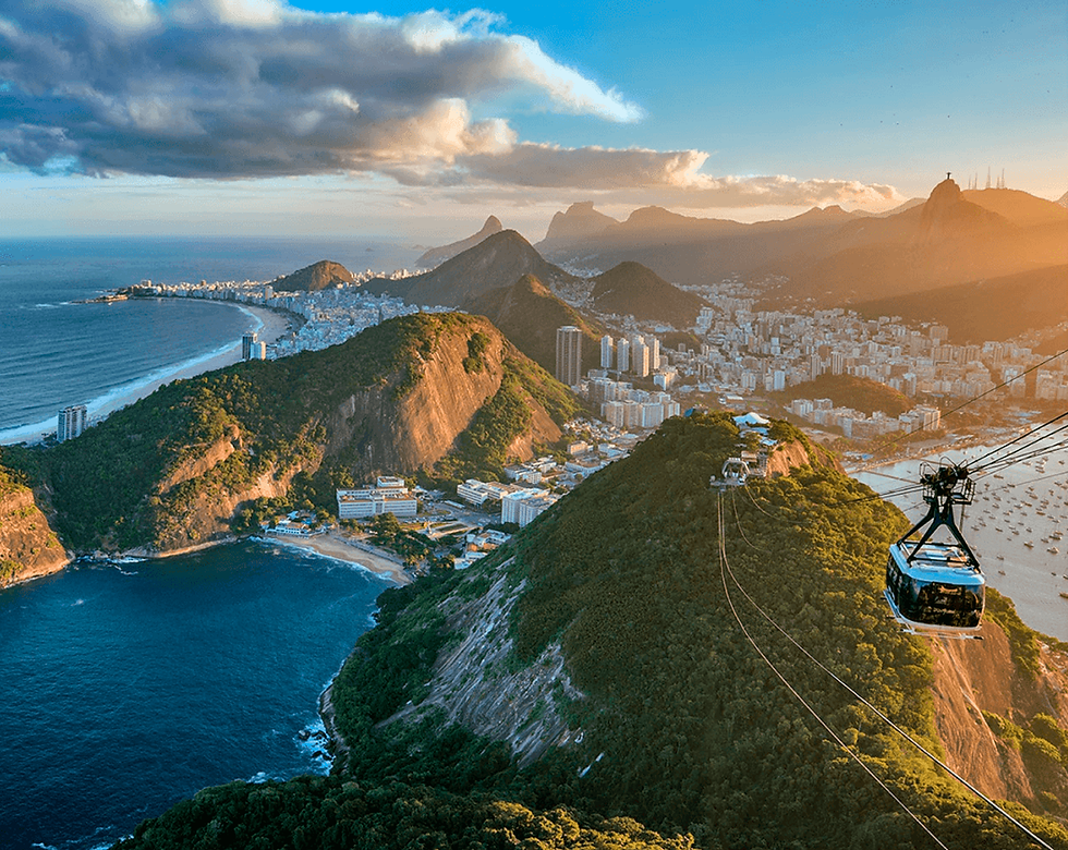
Morro da Urca Trail – A short, easy trail leading to the first peak of Sugarloaf Mountain, where you can enjoy breathtaking views without taking the cable car.
Parque Lage to Corcovado Trail – A beautiful forest trail that ends at the foot of Christ the Redeemer.
⛰️ Trails with Spectacular Views
For those seeking stunning viewpoints, some hikes offer breathtaking panoramas.
Pedra Bonita Trail – Located in São Conrado, this easy trail rewards hikers with an unforgettable view of Pedra da Gávea and São Conrado Beach.
Garganta do Céu Trail – A must-visit trail that perfectly frames Pedra da Gávea between the mountains, creating a cinematic landscape.
💪 Challenging Trails for Adventurers
If you’re up for a real challenge, Rio offers technical trails for experienced hikers.
Pedra da Gávea Trail – One of the most iconic hikes in Brazil, featuring a demanding route and a scrambling section called “Carrasqueira”. The reward? One of the most spectacular views in the world.
🏞️ Waterfalls & Forest Crossings
Beyond mountains, Rio is also home to hiking trails leading to waterfalls and incredible Atlantic Forest crossings.
Cachoeira das Almas Trail (Tijuca National Park) – A perfect light hike ending in a refreshing waterfall.
Horto Waterfalls Trails (Botanical Garden) – A selection of short to long hikes leading to beautiful waterfalls.
🌿⛰️ Rio de Janeiro: A Paradise for Hikers!
If you love hiking, Rio de Janeiro offers some of the most breathtaking trails in Brazil. Here are some of the best trails, divided by difficulty level:
🌱 Easy Trails – Ideal for Beginners

The Morro da Urca Trail is one of the most accessible and enjoyable trails in Rio de Janeiro. It leads to the first stage of the Sugarloaf Cable Car, offering an incredible view of the city without having to pay for the ride.
📌 General Information
Difficulty level: Easy to moderate
Distance: Approximately 1.5 km
Average ascent time: 30 to 40 minutes
Altitude: 220 meters
📍 How to get there?
The trail begins on the Cláudio Coutinho Path, located at Praia Vermelha in the Urca neighborhood. Simply follow the path until you find the sign indicating the trail entrance.
🌿 What to expect?
The path is well-marked and surrounded by Atlantic Forest vegetation.
You may spot marmosets and birds along the way.
The view from the top includes Botafogo Beach, Guanabara Bay, and part of Rio’s South Zone.
At the summit, there is a rest area with bathrooms, snack bars, and an amazing lookout point.
⚠️ Important Tips
✅ Hire a guide – Local guides know points of interest and can provide technical support on difficult sections. They share information about the local fauna, flora, and history, making the experience even more enriching. In case of any issues, a trained guide knows how to act and can administer first aid.
✅ Wear appropriate hiking shoes.
✅ Avoid going after rain, as the trail may become slippery.
✅ Bring water and sunscreen.
✅ If you don’t want to hike back down, you can take the Sugarloaf Cable Car to the base (paying for the descent).
This trail is great for beginners and perfect for those who want a stunning view of Rio without much effort.

Parque Lage to Corcovado Trail – 🌿⛰️
This trail is an amazing adventure for those who want to reach Christ the Redeemer in a more natural and challenging way! It cuts through the Tijuca National Park, passing through dense forest and streams, and requires a good level of physical fitness.
📌 General Information:
Difficulty level: Moderate to difficult
Distance: Approximately 2.2 km
Average ascent time: 2 to 3 hours
Altitude: 710 meters (Christ the Redeemer)
📍 How to get there?
The trail begins inside Parque Lage, in the Jardim Botânico neighborhood. Entrance to the park is free, and the trail starts at the back of the park, passing through the historic mansion.
🌿 What to expect?
Steep and demanding sections, with constant climbs and some areas where you need to use your hands to climb small rocks.
Passage through an old aqueduct and streams, adding a sense of adventure.
The final section features a gate to the Christ the Redeemer area, where you may need to present a ticket to enter the monument or purchase one at a discounted rate for arriving via the trail.
Close contact with nature, including monkeys and birds along the way.
⚠️ Important Tips:
✅ Hire a guide – Local guides know points of interest and can provide technical support on difficult sections. They also share insights about the local flora, fauna, and history, enriching the experience. In case of any problems, a trained guide knows how to act and can provide first aid.
✅ Avoid going alone – The trail has isolated sections, so it's safer to go in a group.
✅ Bring water and snacks – The hike is demanding, and there are no food or drink vendors along the way.
✅ Wear appropriate hiking shoes – The terrain can be slippery, especially after rain.
✅ Start early – The park closes in the late afternoon, and it's best to avoid hiking at night.
✅ Check entrance requirements for Christ the Redeemer – Sometimes, you may need to buy your ticket in advance.
If you're looking for a challenge and a different way to reach Christ the Redeemer, this trail is a fantastic choice!

Pedra Bonita Trail – One of the Most Stunning Views in Rio! 🌄
The Pedra Bonita Trail is one of the easiest and most accessible hikes in Rio de Janeiro, making it perfect for beginners and those looking for spectacular views without much effort. Plus, it is the takeoff point for hang gliding and paragliding, adding an extra thrill to the experience!
📌 General Information:
Difficulty level: Easy to moderate
Distance: Approximately 1.5 km (one way)
Average ascent time: 30 to 40 minutes
Altitude: 693 meters
Location: Tijuca National Park
📍 How to get there?
The trail entrance is on Estrada das Canoas, in São Conrado. You can get there by car (parking is available, but it can be limited) or via ride-hailing apps (signal may be weak, but you can ask for Wi-Fi at Café da Pedra). If taking a bus, get off on Estrada das Canoas and walk to the trail entrance.
🌿 What to expect?
A smooth and well-marked ascent, ideal for beginners.
Close contact with nature, passing through sections of the Atlantic Forest with chances to spot birds and small animals.
Breathtaking views from the top, including Pedra da Gávea, São Conrado Beach, Tijuca Forest, and even parts of Barra da Tijuca.
Hang gliding and paragliding ramp, where you can watch thrilling takeoffs.
⚠️ Important Tips:
✅ Hire a guide – Local guides know the best spots, can provide technical support, and enhance the experience with interesting facts about local wildlife, plants, and history. They are also trained for first aid in case of emergencies.
✅ Wear light clothing and proper footwear – While easy, the trail does have some steep sections.
✅ Bring water and snacks – There are no stores or food stalls at the summit.
✅ Opening hours – Entry is allowed from 8 AM to 2 PM, and the park closes at 5 PM.
✅ Avoid rainy days – The ground can become slippery, making the hike more challenging.
If you’re looking for an easy trail with a mind-blowing view, Pedra Bonita is the perfect choice!

Dona Marta Overlook Trail – One of the Most Stunning Views in Rio! 🌅
The Dona Marta Overlook Trail is one of the easiest hikes in Rio de Janeiro, leading to one of the city's most famous viewpoints, offering a spectacular panoramic view of Christ the Redeemer, Sugarloaf Mountain, Guanabara Bay, and much more.
📌 General Information:
Difficulty level: Easy
Distance: Around 600 meters
Average ascent time: 20 to 30 minutes
Altitude: 360 meters
Location: Tijuca National Park
📍 How to get there?
The trail starts on Estrada das Paineiras, near the Tijuca National Park Visitor Center.
You can reach the starting point by car or ride-hailing app (it’s best to have a driver wait for you since cell service is unreliable for booking a ride back).
If taking a bus, get off at Cosme Velho and take a taxi or van to Paineiras.
Another option is driving directly to the overlook, skipping the hike altogether.
🌿 What to expect?
A short and well-marked trail, ideal for beginners.
Close contact with nature, passing through Atlantic Forest trees and spotting monkeys and birds.
Breathtaking panoramic views, including Christ the Redeemer, Maracanã Stadium, Guanabara Bay, Sugarloaf Mountain, Santos Dumont Airport, and even the Rio-Niterói Bridge.
Great for photography, making it one of the best sunrise spots in Rio.
⚠️ Important Tips:
✅ Hire a guide – Local guides enhance the experience with information about wildlife, history, and local landmarks, and provide first aid if needed.
✅ Wear light clothing and comfortable shoes – The trail is short but has uneven terrain.
✅ Bring a fully charged phone – The trail is safe, but having company and communication is always good.
✅ Bring water and snacks – There are no stores or food stalls at the overlook.
✅ Go early – Sunrises from Dona Marta Overlook are unforgettable!
✅ Be cautious on rainy days – The ground can become slippery.
If you’re looking for a short and easy trail with one of the most spectacular views in Rio, this is a perfect choice!
⛰️ Moderate Trails – For Adventure Lovers

Two Brothers Hill Trail – One of the Most Breathtaking Views in Rio! ⛰️🌅
The Two Brothers Hill Trail is one of the most popular in Rio de Janeiro, offering a spectacular view of the city, including Ipanema and Leblon beaches, Rodrigo de Freitas Lagoon, Christ the Redeemer, and Rocinha. The trail starts within the Vidigal community, providing a unique cultural experience.
📌 General Information:
Difficulty level: Moderate
Distance: Approximately 1.5 km (one way)
Average ascent time: 40 minutes to 1 hour
Altitude: 533 meters
Location: Vidigal, Rio de Janeiro
📍 How to get there?
Go to the entrance of the Vidigal community, accessible by bus, car, or ride-hailing services.
Take a motorbike taxi or van (R$7.00 per person for the round trip) up to the top of Vidigal, where the trail entrance is located (next to the sports center; R$10.00 per person to enter).
From there, the trail continues through the forest to the summit of Two Brothers Hill.
🌿 What to expect?
A moderate ascent, with some steep sections, but nothing too technical.
Contact with Atlantic Forest, with the chance to see small monkeys and birds.
One of the most stunning panoramic views in Rio, covering the South Zone, Christ the Redeemer, Tijuca Forest, Rocinha, and even Niterói.
A unique cultural experience, as the access route passes through Vidigal, one of Rio’s most vibrant and safest communities.
⚠️ Important Tips:
✅ Hire a guide – Local guides know the best spots and can provide technical support in difficult areas. They also share insights about the local fauna, flora, and history, enriching your experience. In case of an emergency, a trained guide knows how to react and provide first aid.
✅ Wear proper hiking shoes – The terrain can be slippery in some areas.
✅ Bring water and snacks – There are no facilities at the top.
✅ Avoid hiking alone – It’s safer to go in a group.
✅ Start early – Sunrise from the summit is one of the most sought-after experiences in Rio, but any time of day offers an unforgettable view!
✅ Avoid rainy days – The trail can become dangerous and visibility may be compromised.
If you're looking for a moderate-level hike with a breathtaking view, this is one of the best options in Rio!

Pedra do Telégrafo Trail – The Famous Cliff Illusion Photo Spot! 📸⛰️
The Pedra do Telégrafo Trail, located in the west zone of Rio, became famous for its stunning photos that create the illusion of hanging off a cliff. Despite its daring appearance, the spot is completely safe and has become one of the most popular destinations for adventurers and photography lovers.
📌 General Information:
Difficulty level: Moderate
Distance: Around 3.5 km (one way)
Average ascent time: 50 minutes to 1 hour
Altitude: 354 meters
Location: Barra de Guaratiba, Rio de Janeiro
📍 How to get there?
Public transportation: Take a bus or metro to Jardim Oceânico Station, then a BRT to Guaratiba. From there, take a local transport to the trail entrance.
Car or ride-hailing service: Access is via Estrada Roberto Burle Marx, Barra de Guaratiba. Parking is available in the area.
The trail starts at Rua Parlon Siqueira, at the top of Barra de Guaratiba. The path is well-marked and passes through stretches of Atlantic Forest.
🌿 What to expect?
A moderate ascent, with some steep sections, but nothing too technical.
Immersion in nature, passing through dense forest areas and scenic viewpoints.
The main attraction: The famous optical illusion rock – in reality, the drop next to it is not as high as it seems in photos.
Breathtaking views of the Restinga da Marambaia, wild beaches, and the city in the distance.
⚠️ Important Tips:
✅ Hire a guide – Local guides know the best spots and can provide technical support. They also share insights about the local wildlife, flora, and history, making the experience even richer. If anything goes wrong, a trained guide knows how to assist and provide first aid.
✅ Go early! The line for photos at the rock can get long, especially on weekends.
✅ Wear proper hiking shoes – Some sections can be slippery.
✅ Bring water and snacks – The heat in the area can be intense.
✅ Avoid rainy days – The terrain becomes more dangerous, and visibility may be affected.
✅ Combine the hike with a visit to the nearby wild beaches – Such as Praia do Perigoso and Praia do Meio, which are worth exploring.
If you’re looking for incredible scenery and thrilling (but safe) photos, this trail is a fantastic option!

Pico da Tijuca Trail – The Highest Point in Tijuca National Park! ⛰️🌿
The Pico da Tijuca Trail leads to the highest peak in Tijuca National Park, standing at 1,021 meters (3,350 feet) above sea level. From the top, you can enjoy a breathtaking panoramic view of Rio de Janeiro, including the Maracanã Stadium, Guanabara Bay, Pedra da Gávea, and even the distant Serra dos Órgãos mountains on clear days.
📌 General Information:
Difficulty level: Moderate
Distance: Around 2.8 km (one way)
Average ascent time: 1h30 to 2h
Altitude: 1,021 meters
Location: Tijuca National Park, Rio de Janeiro
📍 How to get there?
Entrance through the Tijuca National Park Visitors Center in Alto da Boa Vista.
The trail starts near the park’s entrance gate, with clear signs indicating the path.
The route passes through Bom Retiro, a starting point for several other trails in the park, before continuing to the Pico da Tijuca summit.
🌿 What to expect?
A well-marked and safe trail, perfect for those with some hiking experience.
Continuous ascent, but no major technical challenges or climbing required.
Historic stone staircase carved into the rock, built by order of President Washington Luís in 1920.
Spectacular views from the summit, including Maracanã, Downtown Rio, Guanabara Bay, Pedra da Gávea, and more.
Rich wildlife – You might spot monkeys, toucans, and other Atlantic Forest species.
⚠️ Important Tips:
✅ Hire a guide – Local guides know the best spots, provide support in difficult sections, and share knowledge about the wildlife, flora, and history of the region. A trained guide can also assist in case of an emergency.
✅ Go early! Weather conditions at the summit can change quickly, and mornings offer the best visibility.
✅ Bring water and snacks – There are no food or water facilities along the trail.
✅ Wear proper hiking shoes – While the trail is well-marked, some sections can be slippery, especially after rain.
✅ Avoid hiking on rainy days – The ground becomes more dangerous, and fog may obstruct the view.
✅ Combine it with other nearby trails – Tijuca National Park offers several other great hikes, such as Bico do Papagaio Trail and Cachoeira das Almas (Waterfall of Souls).
✅ Follow the signs carefully – There are multiple trail intersections, making it easy to get lost.
If you’re looking for a rewarding and accessible adventure with one of the best views in Rio, Pico da Tijuca is an excellent choice!
🏔️ Difficult Trails – For the Most Experienced

Pedra da Gávea Trail – The Most Challenging and Rewarding Hike in Rio! ⛰️🔥
The Pedra da Gávea Trail is one of the most famous and challenging hikes in Rio de Janeiro. Standing at 844 meters (2,769 feet) above sea level, it is the largest monolith by the sea in the world and offers an absolutely breathtaking view, covering the South Zone, Barra da Tijuca, Christ the Redeemer, and even Niterói.
📌 General Information:
Difficulty level: Hard
Distance: About 3.5 km (one way)
Average hiking time: 2h30 to 3h30
Altitude: 844 meters (2,769 feet)
Location: Tijuca National Park
📍 How to get there?
The trail starts in Barrinha, in Barra da Tijuca, near Praça Professor Velho da Silva. You can get there by car, ride-hailing apps, or bus (you'll need to walk to the park entrance).
🌿 What to expect?
A steep and demanding climb, with challenging inclines and sections requiring scrambling.
The most difficult section: "Carrasqueira", a 30-meter (98-foot) rock wall that requires climbing (it is highly recommended to go with a guide or an experienced hiker).
Rich wildlife and nature, with chances to spot monkeys, toucans, and rare species of the Atlantic Forest.
An unbelievable panoramic view from the summit, one of the most stunning in Brazil, overlooking beaches, mountains, and the city.
The famous "Face of the Emperor", a rock formation that resembles a sculpted face, adding to the mystical charm of the place.
⚠️ Important Tips:
✅ Hire a guide – If it's your first time, it's highly recommended for safety, especially at Carrasqueira. Guides also provide insights into local flora, fauna, and history, making the experience even richer. In case of emergencies, a trained guide can offer first aid.
✅ Wear lightweight clothing and hiking shoes – The trail is physically demanding, and proper footwear makes a huge difference.
✅ Bring water and snacks – The hike is long and exhausting, and there are no food or water sources along the way.
✅ Avoid hiking on rainy days – The trail becomes extremely slippery, and Carrasqueira can be dangerous.
✅ Start early – The hike takes several hours, and you should avoid returning in the dark.
If you're looking for a thrilling adventure with one of the most breathtaking views in Rio, Pedra da Gávea is an unmissable experience!

Garganta do Céu Trail – An Incredible View of Pedra da Gávea! ⛰️☁️
The Garganta do Céu Trail is one of the most breathtaking hikes in Rio de Janeiro, offering a spectacular view of Pedra da Gávea, the ocean, and the city. Though less famous than the main Pedra da Gávea trail, this route leads to a unique viewpoint, where a natural rock formation creates a "window" to paradise.
📌 General Information:
Difficulty level: Moderate to difficult
Distance: Approximately 3 km (one way)
Average hiking time: 2h to 2h30
Altitude: Around 600 meters (1,969 feet)
Location: Tijuca National Park
📍 How to get there?
The trail starts at the same entrance as the Pedra da Gávea Trail, located in Barrinha, Barra da Tijuca, near Praça Professor Velho da Silva. Instead of continuing to the summit of Pedra da Gávea, there is a fork in the trail leading to the Garganta do Céu viewpoint.
🌿 What to expect?
A steep and demanding ascent, including some sections that require scrambling.
Direct contact with nature, passing through dense Atlantic Forest areas.
A stunning viewpoint, offering a perfectly framed view of Pedra da Gávea and the ocean.
Technical and slippery sections, requiring caution and, if possible, a guide for safety.
A great alternative for those seeking a challenge without having to reach Pedra da Gávea’s summit, but still wanting an equally spectacular view.
⚠️ Important Tips:
✅ Hire a guide – Local guides know the trail well, can provide technical support in tricky sections, and share insights about the fauna, flora, and history of the area. In case of an emergency, a trained guide can administer first aid.
✅ Bring water and snacks – There are no supply points along the way.
✅ Wear lightweight clothing and hiking shoes – The path can be slippery in some areas.
✅ Avoid rainy days – The trail can become dangerous when wet.
✅ Start early – To avoid the strong sun and ensure a safer descent.
✅ Consider hiring a guide – Especially if it’s your first time.
If you're looking for a breathtaking view without having to climb all the way to the top of Pedra da Gávea, the Garganta do Céu Trail is a perfect choice!
Why Hire a Guide?
✅ Safety: Some trails have steep climbs, rock scrambles, and potentially dangerous sections for those unfamiliar with the path.
✅ Experience: Local guides know shortcuts, points of interest, and offer technical assistance in difficult sections.
✅ Equipment: On trails like Pedra da Gávea (Carrasqueira section), a guide can provide ropes and harnesses for added safety.
✅ History & Fun Facts: Many guides share fascinating stories about the local wildlife, flora, and history, making the hike even more enjoyable.
✅ Emergency Preparedness: In case of any accidents or issues, a trained guide knows how to respond quickly and effectively.
Need more details or recommendations for a specific trail? Just let me know! 😉🏕️


Comments